Stream Monitoring Event for the Direct Streams Volunteer Group
Stream Monitoring Event for the Direct Streams Volunteer Group
Time
10/19/2020 All Day
Event Details
Volunteers of the Direct Streams group will be monitoring Deans Creek, Paines Creek, Mill Creek, and Townline Creek today as part of CSI’s Synoptic Stream Monitoring Program. These volunteers
Event Details
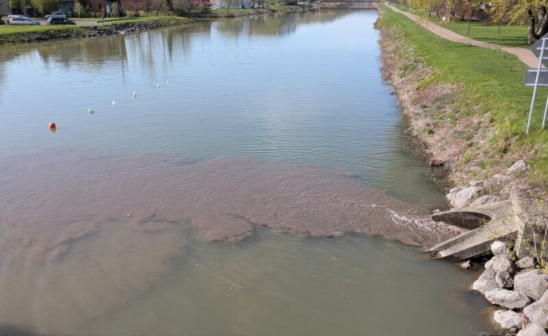
Volunteers of the Direct Streams group will be monitoring Deans Creek, Paines Creek, Mill Creek, and Townline Creek today as part of CSI’s Synoptic Stream Monitoring Program. These volunteers will be collecting field measurements and water samples at 15 locations throughout the watershed. Samples collected by volunteers are analyzed at our EPA certified water testing lab for over 12 characteristics of water quality including nutrients, sediment, and pathogenic bacteria. Visit the Community Partnerships page for more information about the Synoptic Stream Monitoring Program. Volunteers can find a guide to sampling procedure and tracking sheets on the Volunteer Resources page.
The water quality of these creeks was first monitored by the Direct Streams volunteer group in partnership with CSI in 2009. Over 10 years of data show the water in these creeks to have relatively high concentrations of nutrients compared to southern tributaries in the Cayuga Lake watershed. Water samples collected at the mouth of Deans Creek average 185.75 mg/L of total phosphorus during baseflow conditions and average 422.4 mg/L during stormwater conditions. Samples collected at the mouth of Paines Creek average 37.4 mg/L of total phosphorus during baseflow conditions and average 242.3 mg/L during stormwater conditions. Samples collected at the mouth of Mills Creek average 50.23 mg/L of total phosphorus during baseflow conditions and average 399.43 mg/L during stormwater conditions. Samples collected at the mouth of Townline Creek average 99.11 mg/L of total phosphorus during baseflow conditions and average 193.23 mg/L during stormwater conditions. These results can be viewed or downloaded for use on CSI’s public Water Quality Database.
These four creeks flow through the towns of Ledyard, Scipio, Venice, Genoa, and Lansing. Deans Creek and Paines Creek flow into Cayuga Lake in the Village of Aurora. The beautiful Moonshine Falls can be found along Paines Creek.
The Deans Creek watershed is 3.21 square miles of agricultural land (76%), forest and wetlands (19%), and developed land (5%) (NLCD 2016). Paines Creek watershed is 15.36 square miles of agricultural land (76%), forest and wetlands (20%), and developed land (4%). Mill Creek watershed is 3 square miles of agricultural land (86%), forest and wetlands (8%), and developed land (6%), and the Townline Creek watershed is 1.22 square miles of agricultural land (75%), forest and wetlands (18%), and developed land (7%).
If you are interested in helping CSI protect the water of these creeks, please email our Outreach Coordinator Nathaniel Launer.
Organizer
![]()
Community Science Institute
- info@communityscience.org
- (607) 257-6606
- 95 Brown Road
Box 1044/Suite 283
Ithaca, NY 14850
Leave a Comment